It was around ten years ago when I first studied San Francisco’s earliest maps, as being a longtime inhabitant of District 3 I suddenly found them of particular interest. For anyone that’s ever done the same, or has read numerous histories about San Francisco surrounding the California Gold Rush of 1849, there are generally two early maps that get the most attention: one done in 1839 by Jean Jacques Vioget surveying the village of Yerba Buena (located in the vicinity of where the Financial District and Chinatown meet today), and one by Jasper O’Farrell in 1847 which is perhaps most famous for instituting Market Street to the plat of SF, despite it being all sand dunes at that time. But while these two maps tend to get the most attention within the historiography of San Francisco today, there is actually another lesser known map worth knowing about, as well. In fact, its historical importance cannot be overstated, as technically, it was San Francisco’s first official map, and operated as a stop gap between the inherited oblique map of Yerba Buena (descended from Vioget’s) and O’Farrell’s formal survey and map of August 1847. Today, historians refer to this missing-link map as the “Buckelew Map,” “Bartlett Map,” or “Alcalde Map.” I’m fairly certain I first came across this map when reading Geoffrey P. Mawn’s excellent 1971 paper, “Framework for Destiny: San Francisco, 1847”1 (for anyone interested in SF’s early map development I cannot recommend this article enough–if you have a library card it can be easily located and downloaded via JSTOR).
Why is it called the Buckelew Map?
Benjamin Rush Buckelew was born in Monmouth County, New Jersey on March 13, 1822. His father worked as a doctor in Brooklyn, N. Y. on Sands Street.2 It appears as a late-teen, and young adult, Benjamin worked in Brooklyn, as well, where he gained a healthy knowledge of modern mechanic arts like watchmaking, clock making, and probably that of the printing press, as well. In his early 20s, however, perhaps after witnessing the long economic depression in the wake of the Panic of 1837, in early 1846–years before sizable gold mines were found in the west–he and his family joined up with others and made the long and arduous overland journey to California. In Bancroft’s Pioneer Register & Index, he has Buckelew traveling alongside the Hoppe and Harlan families.3 This appears to be a generalization on Bancroft’s part, as he sort of lumps all of the overlanders that year into a general experience, aside from the fate of the Donner Party: “I have the names of about 200 male immigrants who came over the Sierra by the Truckee route,” Bancroft writes, “besides perhaps another hundred of those who probably came that way. I do not suppose the total immigration numbered much more than 500 men, women, and children; though the estimate has generally been higher. . . . Names of immigrants with brief biographic notices are given elsewhere in my Pioneer Register.”4 I was able to locate another much later source, however, that claims of information orally from the Buckelew family. This story tells how Buckelew–along with his wife, Martha, and two children, Cordelia and Frank–joined the Donner Party in Missouri in 1856 “for the trip by wagon train to California,”5 but apparently the Buckelews broke away from the Donner Party and soon after successfully passed through Hastings Cutoff with Captain Samuel C. Young.6 Whether this was a bit of legend passed down over the years (we narrowly escaped the fate of the Donner Party), we cannot know, but . . . whatever the case, after “enduring great hardships,”7 the Buckelews arrived safely in Yerba Buena in the latter part of 1846.

At this time, the Mexican-American War was going on, and just a few months previous, the United States had claimed California as a U. S. territory. Therefore, when the Buckelews arrived, the village of Yerba Buena was controlled by the U. S. military, and the head of the town, its mayor, or alcalde was Washington A. Bartlett. Despite the fact that Alcalde Bartlett had already been in contact with Jasper O’Farrell with regard to a survey of the town, there remained enough friction and debate with regard to municipal funds that by the end of 1846, nothing had been done.8 It appears that it was around this time, that Buckelew entered the fray, perhaps eagerly anticipating the ability to purchase specific lots, especially lots near the promontory that became known as Clark’s Point, which given the shallow waters of Yerba Buena Cove was the cove’s best prospect for a loading off zone.
In mid-December 1846, Alcalde Bartlett was kidnapped, however, by a faction of Francisco Sanchez’s Californio militia. Due to this, U. S. naval officer George Hyde acted as Alcalde ad interim. This is important because unlike Bartlett, Hyde was at this time against the O’Farrell survey, and when O’Farrell subsequently arrived in town, Hyde basically put him about doing work at the fringes of the settlement.9 Then, Hyde gave Buckelew the green light to proceed on a new map, roughly using the oblique Yerba Buena map, to change that map “from an oblique form to that of [a] rectangular plan.”10 According to Buckelew the following year, he had repeatedly and urgently solicited Hyde to allow his doing this at this time.11
In January 1847, after the Battle of Santa Clara and Bartlett’s release, Bartlett published the following ordinance in the California Star after returning to office: “Whereas the local name of Yerba Buena as applied to the settlement or town of San Francisco–is unknown beyond the immediate district. . . It is hereby ordered that the name of San Francisco, shall hereafter be used in all official communications, and public documents, or records appertaining to the town.”12 The fact is, up to that time, while San Francisco Bay was known as such, and there were those that considered the entire peninsula as San Francisco, there were in fact three very distinct settlements: the Presidio of San Francisco (which was mostly desolate by this time), the Mission Dolores Settlement (which had become the last bastion of the upper peninsula’s Californios), and Yerba Buena. What Bartlett was doing here was abolishing the Yerba Buena name–now primarily an Anglo settlement (especially since the U. S. military had taken control of it the previous year)–and telling the world (remember that at this time, papers would travel via ships to other parts of the U. S. and world) that from now on this town is the main settlement in the San Francisco Bay Area, and it’s called San Francisco.
A few weeks after this ordinance was declared, Buckelew completed his map, and on Feb. 22, 1847 Alcalde Bartlett certified it. Therefore Buckelew’s map became the first official map of San Francisco.
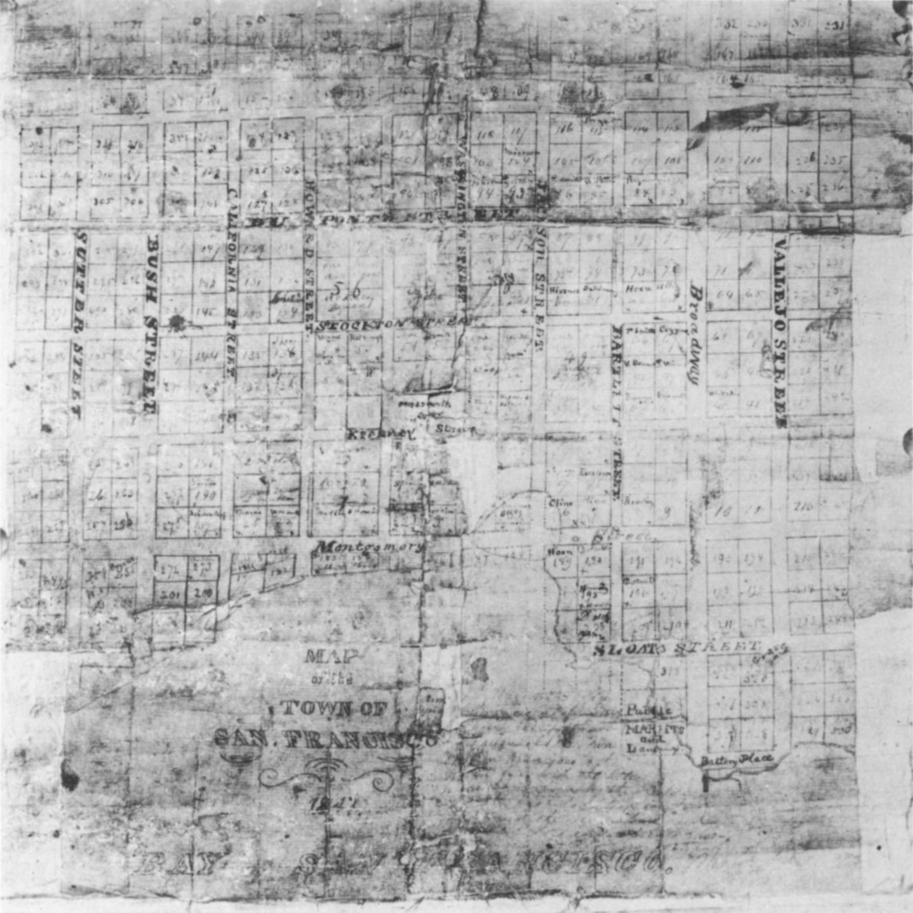
With regard to street names, there are some interesting nuances to note in Buckelew’s map:
- Stockton Street was the original name of today’s Grant Avenue, and Dupont Street was the original name of today’s Stockton Street. Is it possible that given these two guys loathed one another at this time during the Mexican-American War, that someone eventually decided that having Stockton and Kearny streets close to one another was an abomination? Probably not, but it is interesting how the Stockton and Dupont street names were soon after flipped on O’Farrell’s map. However, Stockton’s original location here does appear to clear up why in old writings and reflections you sometimes hear of Samuel Brannan’s home as being on Stockton.
- Today’s Pacific Avenue–which would become a major artery during the gold rush, and the heart of the Barbary Coast in its wake–was originally Bartlett Street. Was this Alcalde Bartlett’s idea, or was Buckelew just buttering Bartlett up on his return, and hoping for more land grants? I kid, but this was changed to Pacific Street by O’Farrell’s map later in the year. Bartlett Street would eventually return to the city, located in the Mission District, though that could be due to another Washington Bartlett.
- Clay Street does not appear to have been named yet, and may have still been referred to as Portsmouth Street. It was noted as Clay Street by O’Farrell’s map, and the first mention of Clay Street I could locate in the papers is from October 1847.14 Of course it was named for Henry Clay of Kentucky.
- Today’s Sacramento Street was known as Howard Street, after William D. M. Howard, an early Yerba Buena settler and merchant. With O’Farrell’s survey, this was changed to Sacramento, and Howard was moved south of Market Street, where it remains today.
- Today’s Sansome Street is here Sloat Street, named for John D. Sloat. This later change could have had something to do with George Hyde’s influence later in 1847, perhaps, given he was from Philadelphia. [Note that in Philadelphia it is spelled Sansom Street, however, but this, without the “e,” was also a common spelling of the San Francisco street in the early days, etc.] It is worth noting, as well, that O’Farrell’s survey added a lot of Philadelphia street names to streets that expanded out from Buckelew’s map: Chestnut, Filbert, Pine, Market, Front, etc. Sloat Street would eventually return to SF where it is located today in the SW portion of the city as Sloat Boulevard.
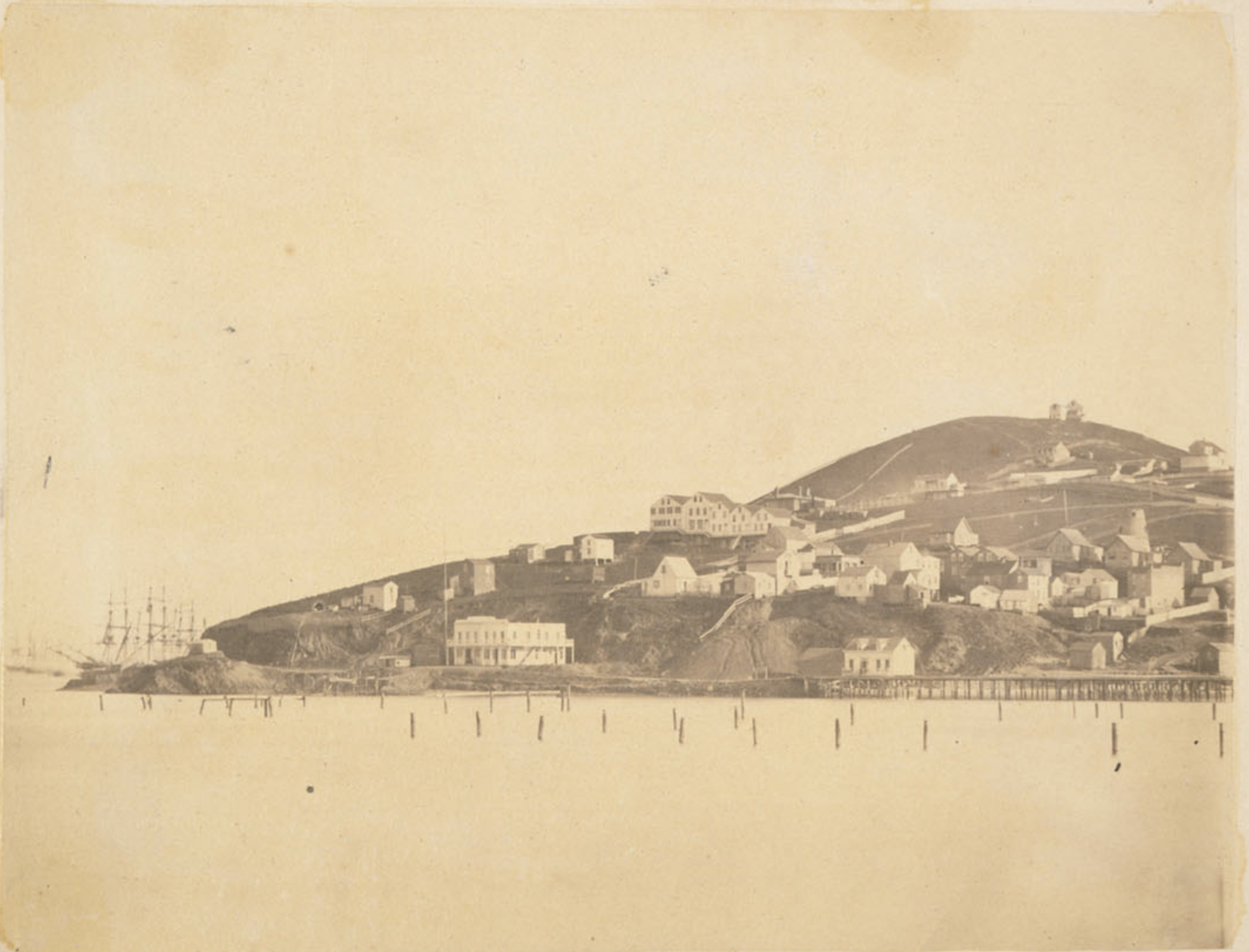
- Battery Street was at this time only one block long, known as Battery Place, as there at the NE of the town was a promontory (later known most widely as Clark’s Point) where a battery had been placed for the defense of Yerba Buena Cove.
One last thing to mention with regard to Buckelew’s map–especially in the case that you’ve heard of this phrase–is what came to be known as “O’Farrell’s Swing” with regard to O’Farrell’s survey later in 1847. This was due to the fact that Buckelew apparently did not do any actual surveying. He just took the inherited, oblique map, straightened it out into a rectangular pattern on paper, and extended it outward in each direction so that the sale of and granting of lots could carry on as soon as possible. [When visitors to SF from other parts of the world are completely puzzled as to why the streets go up and over the hills as if no thought to topography, this is ultimately the reason for that: while extended even further by O’Farrell, no one could then know that a gold rush was about to happen, and that the place would explode, therefore rapidly moving up and over the hills. And when that did happen, the rectangular grid survey was what town officials had to work with.] So when O’Farrell started actually surveying on the ground using Buckelew’s map as his basis (again, versus the old, oblique map), he quickly realized he had to bring the streets that existed already into the parameters of Buckelew’s map and his own ongoing survey, therefore shifting some streets by significant degrees. “The corner of Washington and Kearny streets was the pivot for these corrections.”15
***
When Buckelew arrived in Yerba Buena in 1846,16 he was 24. Yerba Buena was about 350 people, and was already growing with “wonderful rapidity.”17 By mid-1847, as Buckelew’s map was being used for official business, the newly named town of San Francisco was made up of around 500.18 At this time, Buckelew also became part of the town’s leadership, serving on the Town Council (carryover of the Ayuntamiento under the Mexican political system).19 Furthermore, in July 1847, Buckelew purchased the Californian newspaper from Dr. Robert Semple (who had recently moved the paper up from Monterey in May). Buckelew remained publisher and owner of the Californian for a little over a year, selling it to Jacob D. Hoppe, Henry L. Sheldon, and Joseph Dockrill in May 1848, after a majority of the town’s inhabitants had fled to the mines, therefore making it difficult to sustain a paper.20 Lastly, during 1847 Buckelew opened and operated a watchmaker, clock, and jewelry shop at Clark’s Point.21 Of this store, and building, Bancroft notes: “This region was sometimes known as Buckelew Point. It would seem that in this building must have been the office of the Californian [in addition to his watchmaker’s shop]; at least, nobody remembers it elsewhere.”22
As time goes on, it becomes clear that Buckelew obtained a lot of property around “Buckelew Point” (again, more commonly known in SF lore as Clark’s Point) at this time. More than he could do anything with. In fact, somewhat humorously in mid-1848, a few months after the initial gold find at Sutter’s Mill, perhaps due to the influx of miners and types that enjoyed getting inebriated, Buckelew ran a notice in the paper calling for the “erection of a commodious Temperance House of public entertainment” which he would for free lease a lot in perpetuity, as long as taxes and building expenses were covered by the proprietor.24
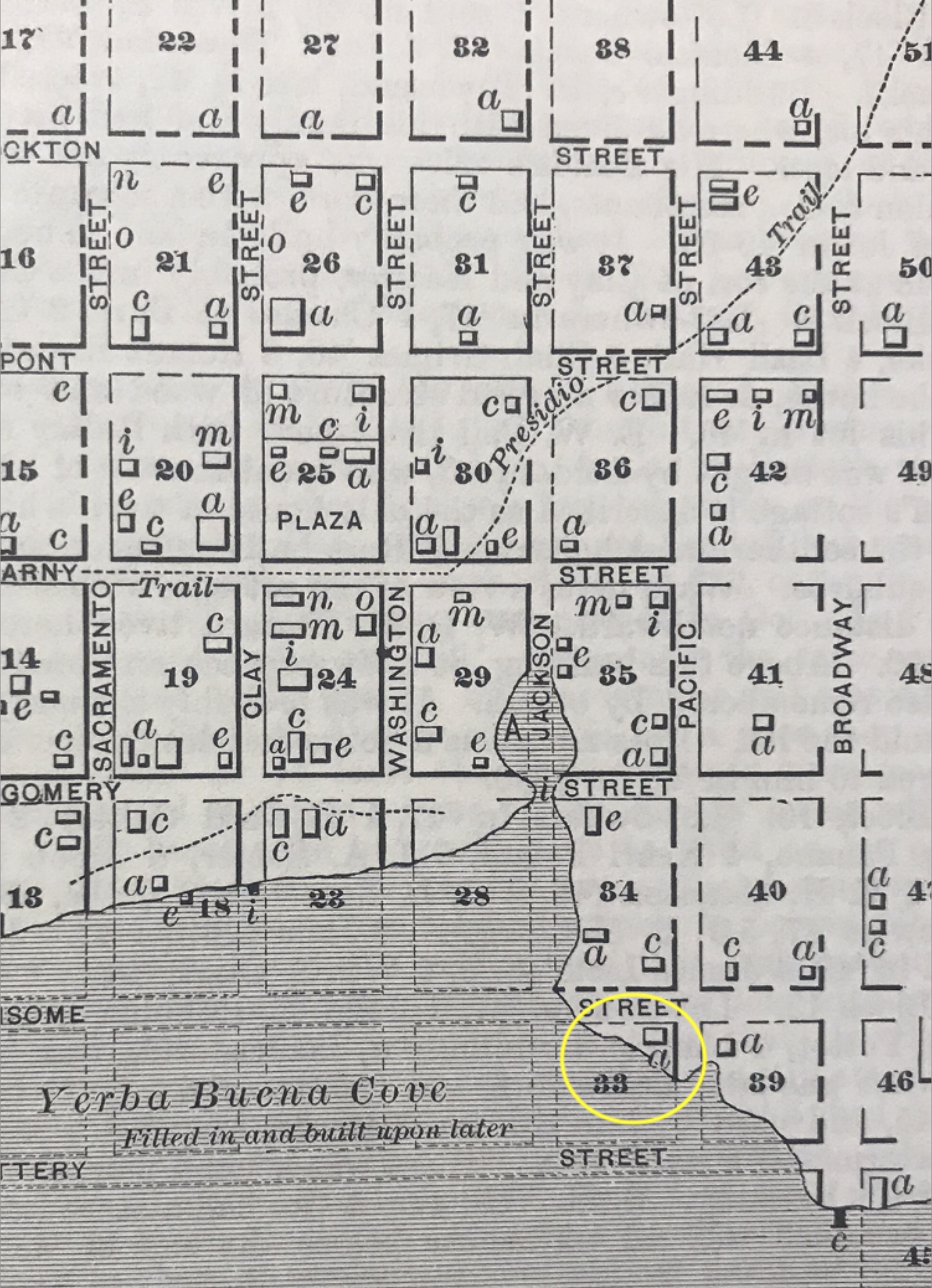
While I am not certain if there were any takers with regard to his offer above, what is clear is that the town around him was beginning to feel the foreshadowing of what would become known as the California Gold Rush of 1849. More and more people arriving daily, some going off to the mines, others staying in San Francisco. While there had been just hundreds of inhabitants when Buckelew arrived, now he was witnessing a transient population of thousands, and while this presented business opportunities for him and others that had been settled there for some time, there was also a chaotic element to it that was quite intense. At the beginning of 1849, Buckelew was selling lots from lot 39 on the above map, as well as around Broadway Wharf, etc., all “excellent commercial business stands.”25
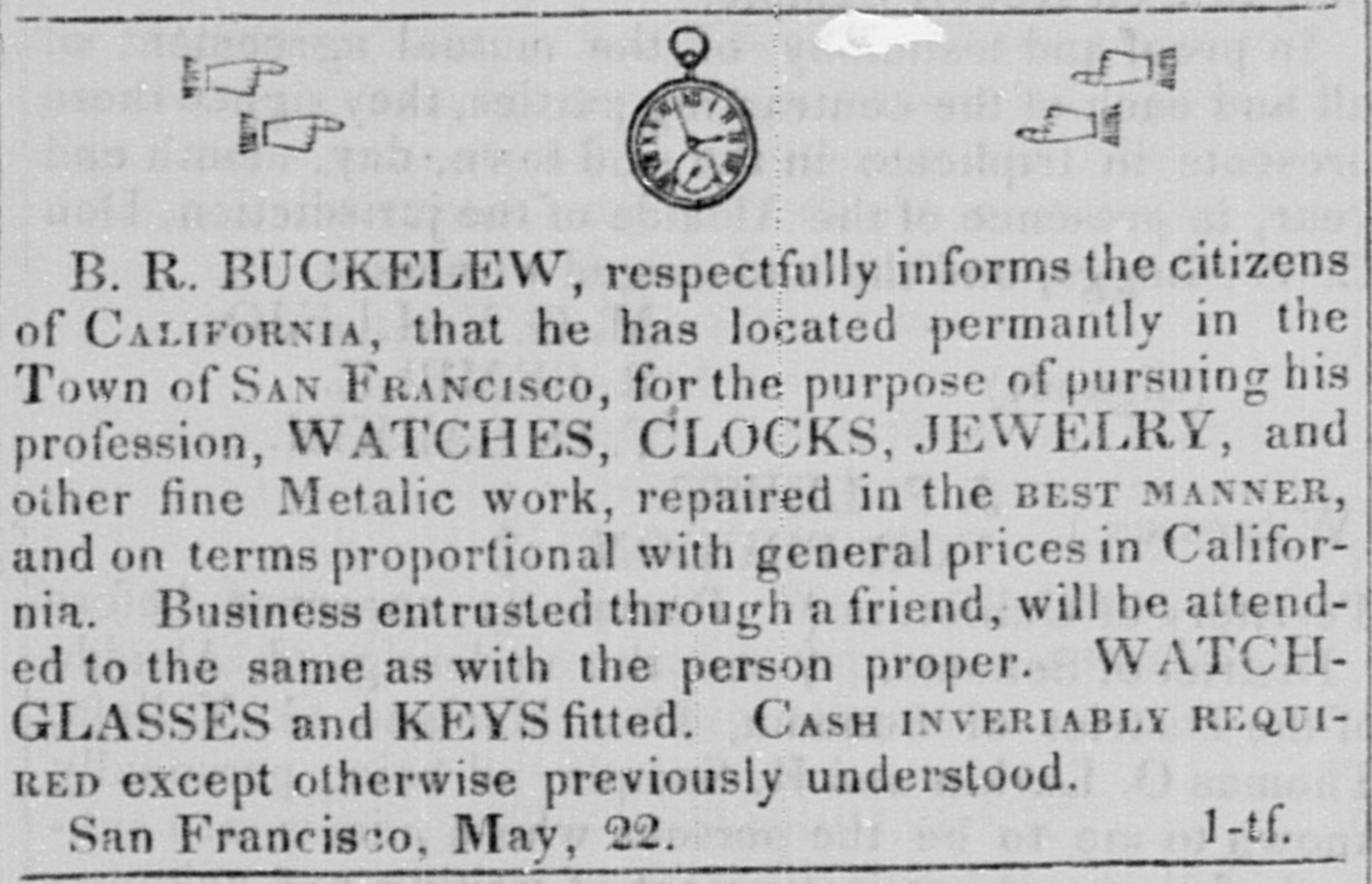
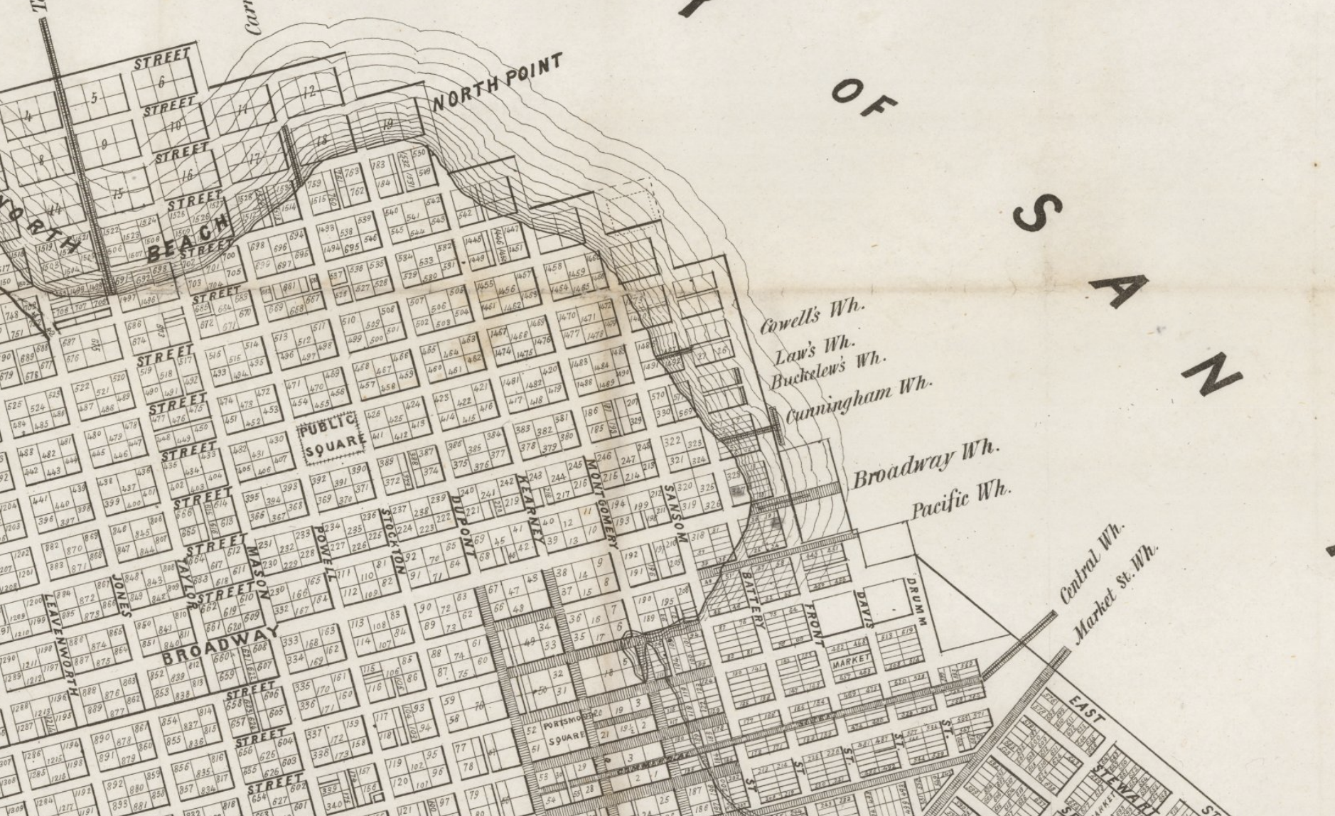
Buckelew moved his watchmaking operation to one of these business stands, which was located along Jackson Street Wharf about a block over Yerba Buena Cove, at the southwest corner of Jackson and Sansome (lot 28 above). It appears he had a large painted watch either above the stand, on a sign, or on its outer wall(s), as his advertisements stated the stand simply as, Sign of the Watch. There he kept on hand a “large assortment of watch-glasses; also keys; hours, minutes and seconds dial hands, main springs, fuzee chains, and other materials for repairs.”26 Upon this lot–located in what is today known as the Jackson Square Historic District–Buckelew was eventually developing on some of the first landfill lots of San Francisco. Also at this time–beginning of 1849–Buckelew helped fund the construction of a small wharf at the foot of Pacific Street.27 This wharf became a huge boon to this area of town as it became the main loading off point for ships. Due to this origin, eventually Pacific Street would eventually become, famously, and notoriously known as the Barbary Coast.
It is worth noting here as well, in early 1849, in what appears to have been one of Buckelew’s last involvements with the political leadership of San Francisco (he was later a candidate in a number of elections, but was never elected), he was appointed secretary for Free Soil meetings with regard to stamping out the possibility of the U. S. government allowing the introduction of slavery into California.28 Not yet a state of the Union at this time (that would not happen until September 1850), the slavery debate was ongoing, and this meeting was instrumental in fostering the movement that would eventually inaugurate it as a Free State. Note, however, that though California did eventually become a Free State with regard to slavery, there were however racist laws within California’s constitution that initially limited the rights of Black citizens. (For more see my article published in The Argonaut, “Exodus: SF’s Black Community in the 1850s.”)
In April 1849, Buckelew began to shift gears a bit, and decided to focus more on the advantages of his location for shipping and mercantile pursuits versus watchmaking, therefore he turned over his watchmaking business to one, George Seddon.29 As Buckelew started making plans to start this new general mercantile and commission business, he first built a new building near the crossing of Jackson and Sansome. It appears this may be the brick building on Gold Street he was long associated with after,30 but I can’t be sure. Whatever the case, with a master plan in mind, Buckelew left San Francisco for New York City aboard a steamer on Dec. 1, 1849, having turned things over to John Cowell and John Buckelew. For a time, they would operate out of this building as Cowell & Buckelew.31

On returning to San Francisco in the spring of 1850, Buckelew’s new business pursuits fell into major action. Now represented by W. Carpenter & Co. in New York City, Cowell & Buckelew started running ads on both coasts.32 Furthermore, along with two more Buckelews from New York, Buckelew established B. R. Buckelew & Co.,33 and started searching for a “large, sound and substantial square built flat bottomed ship hull.”34 You want classic Gold Rush-era San Francisco? Well, this is it: Buckelew was eventually successful in getting what he wanted, and this new store became known as “Buckelew’s Store Ship.”35 This store ship appears to have been located just across Jackson Street from the Cowell & Buckelew brick building, both just west of Sansome, an area once under water, then a wharf with stands, now considered the “foot of Jackson Street.”36
Aside from his mercantile business, Buckelew had other plans, as well. While in New York, he had put plans in motion to erect California Iron & Brass Foundry & Machine Works “on a scale sufficiently extensive to supply the great and growing wants of California and the Pacific Ocean. Steam, agricultural, and all other machinery will be made and repaired to order.”37 Eventually the extensive machinery that Buckelew imported was purchased by others who started Vulcan Foundry & Machine Works at 1st and Mellus [original name of Natoma when it ran all the way between 1st and 3rd38] streets South of Market (then known as Happy Valley).39
As well, along with other early-SF settlers and lot owners like Stevenson & Parker, E. P. Jones, and Thomas Hood, Buckelew pitched in to build a “wide road around the beach to North Bay.”40 This extreme and costly project developed the coast north along the eastern foot of Telegraph Hill, in essence the project forerunner for that area becoming the heart of San Francisco’s shipping industry once Yerba Buena Cove was totally filled in. A part of this “road” became known as Buckelew’s Wharf or Buckelew’s Pier,41 and was created using fill of stone and earth. In fact, Buckelew’s Wharf was such a success structurally, and considered so “sufficiently advanced”42 that in mid-1850 the Pacific Mail Steamship Co. immediately began using it for their operations.
While business was extremely lucrative for Buckelew in 1850, as it was for other commission merchants around town, with SF gaining population daily and thoroughly exploding into a city, it was also at this time that the chaos hit Buckelew’s relationships within San Francisco, within its leadership, and those he had done business with as well. For instance, on Buckelew’s return to the city, he had apparently worked out a deal with the Board of Aldermen (Board of Supervisors today) to personally grade Sansome Street from roughly Jackson to Broadway, approximately, near his lot (above map, lot 39), but “instead of fulfulling the compact [contract?], he excavated an immense tunnel leading from Broadway, taking up the whole of Sansom [sic] Street, and having dug far enough to render his property acceptable, the work was discontinued, leaving at one end of the street an abrupt embankment of at least twenty-five feet high. This of course put a stop to further communication with Broadway, from the street running parallel, and most effectually barricading the thoroughfare. [Buckelew] was notified on various occasions by the authorities, but he invariably expressed himself independent of any power, or any authority.”43 Given this, the Board passed a resolution to make Buckelew accountable. The resolution stated that if he refused to honor the original agreement, then the city had the right to get the work done, and sue Buckelew for the expense of the job. After the resolution passed, the Daily Alta reported Buckelew “rose from a seat among the audience, and in a threatening, bragadocio [sic], and ungentlemanly manner, gave vent to the following specimen of oratory:–‘You’ll have to pay some money getting that resolution through.'”44 It was ordered for the Sergeant-at-Arms to arrest Buckelew, and bring him back into the chamber. “On leaving . . . he continued his abusive and ungentlemanly remarks, until taken from the building.”45 A few days later, Buckelew was fined $100 [about $3,750 today] for his defiant performance.46
There are a few things noticeable in Buckelew’s life at this time. The first appears to be a slight since of inflation (no pun intended, but in a psychological sense) with regard to his monetary station at this time; and two: there was definitely a part of him that felt special due to the fact that he had been in this place since 1846, that is, before the California Gold Rush of 1849 which brought these other pioneers who were now in charge of the city–I mean Buckelew had been part of the Ayuntamiento when the city was still roughly using the Mexican political system, who are they to tell him what to do?! Anyway, in wake of the resignations of F. W. Macondray and W. M. Burgoyne from the Board of Aldermen, an election was held just a month after the incident above, and Buckelew decided to run for a seat on the Board with a People’s Independent platform, his tagline: “Moderate taxation & judicious expenditures–No salaries for Aldermen.”47 Furthermore, Buckelew’s literature went on: “From this gentleman’s long residence in San Francisco, his general business capacity, and his intimate acquaintance with the affairs of this city, together with his unsurpassed liberality and public spirit, renders him in a high degree qualified to discharge the duties of that office.”48 Ultimately, however, Buckelew was not elected, by thirteen votes.49
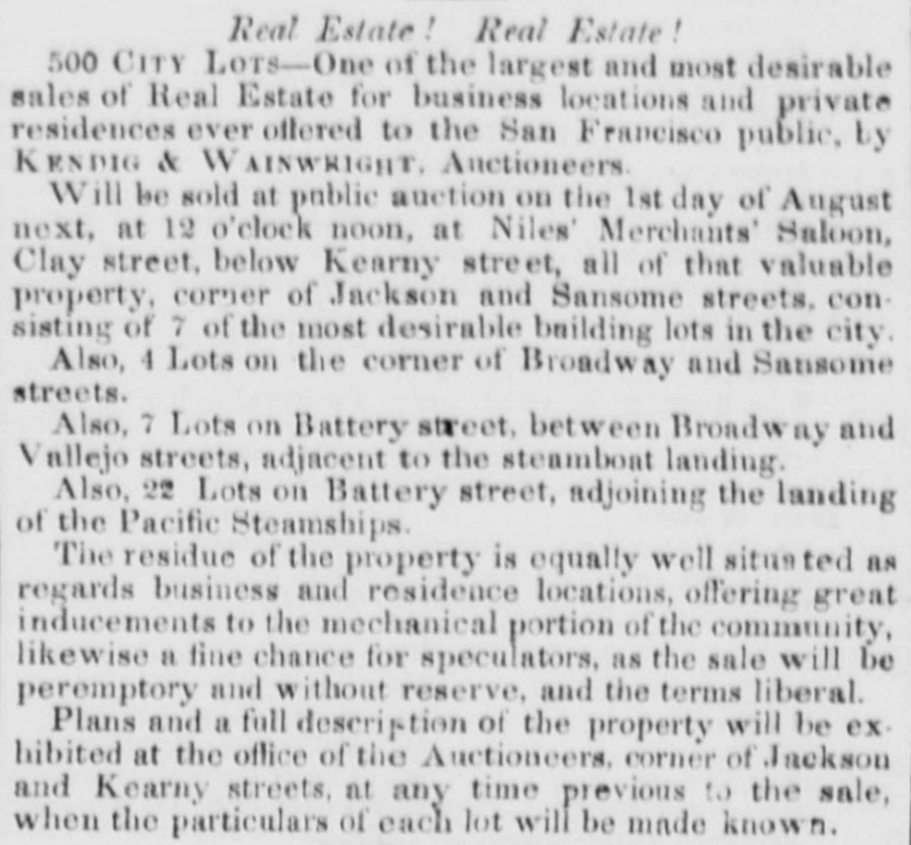
Following this political loss, Buckelew announced he was selling off most all of his undeveloped property in San Francisco, which divided into its smallest possible fractions apparently equaled around 500 lots of real estate. If that was slight exaggeration on the realtor’s part, there is no doubting that these lots at the foot of what is known today as the Jackson Square
Historic District were valuable prospects at that time, and Buckelew was hoping to sell high. In retrospect, this sale was to transform that neighborhood. The sale of these lots ended up netting Buckelew between $60-70,000 [around $2.5M today].50
In the wake of California becoming an actual state of the Union in September 1850, Buckelew ran for office again, as an Independent candidate (again), but this time for the California State Assembly. He did not win. Not only did he not win, but he came in last of thirteen candidates.51 Perhaps angered, and bitter with resentment regarding his earlier altercation with San Francisco’s leadership, and with money to go around, Buckelew started a newspaper. Due to the Alta California now being the prime paper, it appears Buckelew hoped to give it some competition, and also, he had a bit of a bone to pick given they were the ones smearing his name. He had printing press equipment sent from New York, and started the Public Balance on Gold Street in December 1850. Does this have anything to do with the name of Balance Street? It seems possible, as Balance Street doesn’t appear to show up in a newspaper until 1851.52 Buckelew started this paper because he could, but he apparently wanted nothing to do with its operations, therefore he put Eugene Casserly in charge of it.
But just a month after its first issue, Buckelew and Casserly get into a tangle, and Casserly took off to publish his paper at a different facility. Due to this, Buckelew took over the helm of his printing shop and published a new #1 of the Public Balance. The Sacramento Transcript reported, “Farewell to No. 35, hello No. One. There seems to be trouble in the camp.”53 Casserly’s new paper was coming out at the same time with a similar name (perhaps he was the one that initially named it), the Daily Public Balance or Daily Balance. Due to this, Buckelew decided to sue Casserly, mostly out of spite it seems, versus having any legit legal foundation. At this time, Buckelew started calling his paper Buckelew’s Balance,54 and Casserly began printing his paper as the Standard.55 When the lawsuit was presented in court in June 1851, it was thrown out as a “nonsuit,” that is, the court saw no legal grounds for the lawsuit, or any actual case against the defendant.56 This was foreshadowing for what was soon to come for Buckelew with regard to legal matters.
***
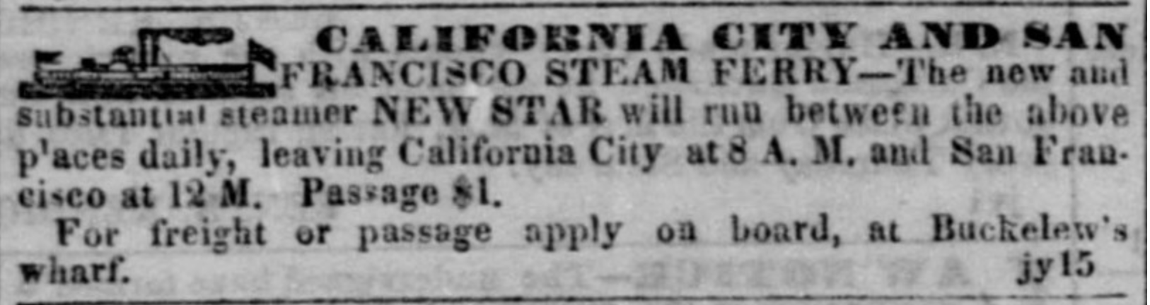
After selling off the majority of his SF lots, Buckelew had also purchased an old Mexican rancho known as Punta de Quentin from early-California settler John Bautista Roger Cooper. The rancho was located across the bay in Marin County. Given this, Buckelew had moved his family to Marin County, though due to his daily dealings in the city, he purchased a steamer called the New Star which would ferry him from Marin County to Buckelew’s Wharf in SF each day.57 After purchasing Punta de Quentin, Buckelew apparently had a section of it roughly surveyed, and petitioned to turn it into a legal township. The name he gave to this new place was California City. Within today’s lore, particularly among Marin County historians, it’s assumed that on doing this that Buckelew seriously aspired to create some new San Francisco or New York in this new place, but I personally don’t think this is the case, at all. I think Buckelew did this because he could, and anything after this, with regard to SF, was out of resentment. He began to relish his outcast position, and started messing with the public via newspapers with sarcastic humor.
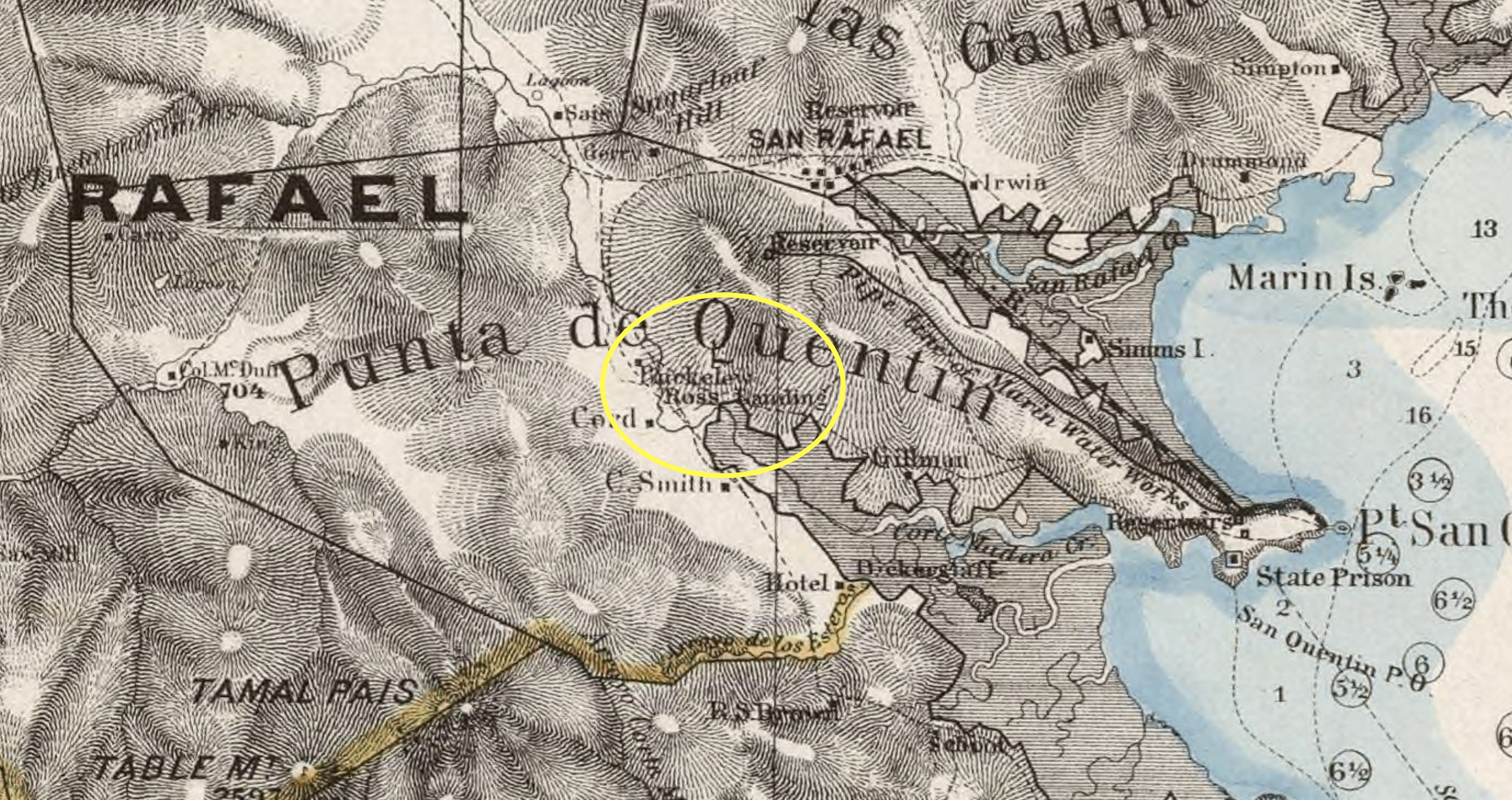
Given various things I’ve seen, it’s important to talk about the location of Buckelew’s California City, as in the above mentioned Marin County lore their location appears to be incorrect. For instance, I saw on a Marin County historical website that California City was located where Paradise Cay is today. Not to be pedantic, but this can’t be right, as not only is much of Paradise Cay on land filled in later (as I understand it), but also, and most importantly, California City was located within the bounds of the Punta de Quentin rancho, and furthermore, the Buckelew’s house was widely known to have been in today’s Ross, which at that time was considered in California City. Below is a geological survey of “the region adjacent to the Bay of San Francisco” which was primarily performed in the 1860s by topographer C. F. Hoffmann. It shows the precise bounds of Punta de Quentin, and where the Buckelew home was located.58 [See footnote for more.]
In early 1851 (perhaps before being totally settled in Marin County), Buckelew was suffering “continued ill-health”59 and therefore decided to sell off his newspaper and printing equipment. Furthermore, in what appears to suggest Buckelew was suffering from tuberculosis, then known as “consumption,” he took off on a steamer with his family, down the coast, for fresh air, etc.60
Once returned to health, and back in the Bay Area, Buckelew started getting hit with lawsuits from all angles. It would be exhaustive for me to mention each case specifically, but I can say that they mostly all involved persons Buckelew had done business with at some time or other, and in almost every case Buckelew lost the suit. It’s sort of wild to think this, but I just want to point this out: at this moment, Buckelew was 29 years old, and in the scope of the Yerba Buena to San Francisco shift, he had been one of the younger immigrants on arrival, therefore witnessing a lot in the previous five years which is difficult to elucidate to our minds today, but let me try: the California Gold Rush-era affected those involved like dog years, for instance, a few years after this, when Buckelew expressed his interest in starting another newspaper, though it had been just ten years previous when he was publisher of the Californian he was now considered “an old newspaper man.”61
To back up my thoughts on Buckelew and California City, take this sarcastic advertisement he ran in the Daily Alta in mid-1852: “GREAT EXCITEMENT . . . California City is now but 18 months old, and has already TWO inhabitants, one gentleman and one lady–the number of male and female inhabitants thus being equal, a very remarkable circumstance in the history of this State.”62 [Anyone knowing about the ratio of men to women in SF during the gold rush may find this humorous.] In the rest of this faux advertisement Buckelew basically projects his resentments into the ways he felt he had aided the industry of SF, but instead of being appreciated in any sense, he’s having to steamboat into SF everyday because of lawsuits. It’s all caricature. This is not someone genuinely trying to bolster interest in some new city, or real estate boom. “Balloons are constantly kept on hand for ascending the heights,” Buckelew writes, “from which the once flourishing but now decaying city of San Francisco can be viewed sinking into insignificance before the rising prospects of this wonderful city. Should the Legislature conclude to make this the permanent capital of the State, a donation will be made of three million acres of land, ‘half a million’ in cash, together with a valuable stone quarry, clam-bed and slaughter pen!”63 If this isn’t enough, Buckelew tellingly signs off as, “B. R. Humbug.”64
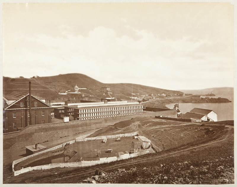
Carrying on in this farcical fashion, yet elevating it to a surreal level on the physical plane that can boggle the mind, later that year it comes out in the papers that Buckelew has offered California Gov. John Bigler a twenty acre section of California City for building a State Prison. Furthermore, the State Legislature is seriously considering it, and indeed pulls the trigger. The land is at the southeastern most point of California City, on a promontory known as Point San Quentin. Buckelew sold the land to the state for $10,000 [$380,000 today], along with a promise to build a wharf for the prison, as well.65 From the way it reads in the papers, it was almost like before anyone could even consider it, it was a done deal. Didn’t Martinez offer land for free? But the Punta de Quentin grant is still in question . . . What if it isn’t confirmed? What about squatters that are already on these acres?66 Though this contract would eventually lead to an investigation in 1853, the building of the State Prison at Point San Quentin happened in the fall of 1852.
Following this triumph from Buckelew’s perspective–up to then keeping a fairly low profile aside from attending to his many ongoing lawsuits–in 1854 Buckelew published another strange proposition in the papers, this time with a more serious tone, “proposing to apply to the Legislature for a monopoly of the steamboat travel on all the large bays in our vicinity, and agrees to pay damages for all persons killed or injured in transportation.”67 In Buckelew’s proposal, he prays that “if the public give me this monopoly, I will give them in return safety, speed, and comfort in their transit.”68 At this point, however, his appeal is mostly slammed and laughed at in the papers, and Buckelew isn’t really heard from again until the onset of the Post-Gold Rush Depression. (I speak more in detail about the Post-Gold Rush Depression in my article about Charles Cushman.)
In fact, this economic turn spurned Buckelew to respond by lofting up his new lumber operations in Marin County, called the Marin City Saw Mill, and looking to hire people, and therefore start a lumber and brick operation which brought building materials to SF, using on the SF side a lot he’d kept at North Point, where he put up a small office/house. As he advertised for these operations, he also took the time to rail against that which had been boiling within him for the past few years: “I am down on the lawyers, as they are (and have been for the last four years) emptying your pockets and mine into their own, and are fast absorbing the property of the country.”69
At the outset of the Post-Gold Rush Depression, Buckelew was a signee of confidence for the banking house of Page & Bacon70 (again, see my Cushman article for more on the SF financial crisis of 1855, specifically pp. 40-42), but one of the stranger twists regarding Buckelew comes when in the aftermath of the run on the SF banks, the missing Adams & Co. books are found by a worker of Buckelew’s at North Point (as if someone had tried to dispose of them in the bay, etc.). The worker said he hid them in Buckelew’s North Point block-house office, which is where they were located when police ransacked the place.71 In the wake of the Post-Gold Rush Depression, Buckelew kept Marin City Saw Mill in process,72 until it bothered commitments he’d made to James Ross and John and Henry Cowell. While the situation appears extremely complex (and outside of my research capacities at the moment), from what I can tell is that Buckelew apparently mortgaged sections of Punta de Quentin to them, but without ever paying them cash on these mortgages kept cutting trees within the mortgaged bounds, and this is what brought them into court.73
Ultimately, in the wake of the Post-Gold Rush Depression, Buckelew would remain embroiled in legal matters while continuing on with this lumber operation, to some degree. In mid-1859, he announced that he hoped to soon start another newspaper in San Francisco, this time to be called the Public Ballot.74 Always a man of many plans, and projects, it so happened however that in the early fall of 1859, Buckelew’s tuberculosis resurrected itself in an undeniable bout. Buckelew wrote out his will on Oct. 28,75 and then died on Nov. 18, 1859, at the age of 37. It appears that this onslaught of TB had to do with a “lingering illness, contracted when drenched with water while crossing San Francisco Bay in a row boat.”76
While perhaps not the most beloved Californian on his exit from this mortal coil (I choose not to mention some of the wild stuff written in the obits at the time as they mostly reflect the antagonism he had with newspapers for much of his post-gold rush life), there is no denying Buckelew’s role as an important and singular California pioneer. Completely lost to history, he was not only the author of San Francisco’s first official map, and instrumental in the city’s early growth and infrastructure, specifically the future Barbary Coast and today’s Jackson Square Historic District, but furthermore, when San Quentin is discussed today, who remembers California City and Benjamin Buckelew? In retrospect however, and to Buckelew’s psychological slapstick credit, San Quentin was California City’s greatest achievement. Californians and historians alike, take note.
Notes
——-
1 Geoffrey P. Mawn, “Framework for Destiny: San Francisco, 1847,” California Historical Quarterly, Vol. 51, No. 2, Summer 1972. This paper won Mawn the 1971 California History Prize, and was therefore published the following year in the California Historical Quarterly.
2 The Long-Island Star, May 25, 1826.
3 Hubert H. Bancroft, History of California, Vol. II (San Francisco: A. L. Bancroft & Co., 1885), 734.
4 Bancroft, Vol. V, 526-527. Furthermore, I was unable to locate any mention of Buckelew in Harlan’s book, etc.
5 Mill Valley Record, May 9, 1941.
6 Ibid.
7 Ibid.
8 Mawn, 166-167.
9 Mawn, 167.
10 Californian, Nov. 4, 1848; Mawn, 168.
11 Californian, Nov. 4, 1848.
12 California Star, Jan. 23, 1847.
13 Mawn, 168.
14 Californian Oct. 13, 1847.
15 Mawn, 169.
16 San Diego Herald, May 20, 1854.
17 Frank Soule, John Gihon, and James Nisbet, The Annals of San Francisco (New York: D. Appleton & Company, 1854), 173.
18 Annals, 174.
19 Annals, 196 & 206; Bancroft, Vol. V, 648-9.
20 Californian, July 17, 1847; Californian, May 10, 1848; Bancroft, Vol. V, 658.
21 California Star, April 24, 1847; Bancroft, Vol. II, 734.
22 Bancroft, Vol. V, 684.
23 Ibid.
24 Californian, May 17, 1848.
25 Weekly Alta, Feb. 15, 1849. The use of “stands” here is important, as it seems to suggest we are talking about water lots here where these “stands” can be constructed along the wharf, which was then an extension of the street (until eventually all of it was filled in).
26 Weekly Alta, Feb. 1, 1849; Nov. 22, 1849.
27 Weekly Alta, Aug 31, 1849.
28 Weekly Alta, Feb. 22, 1849; Mar. 22, 1849.
29 Weekly Alta, April 12, 1849.
30 While ads for Buckelew’s early stand were for SW corner of Jackson and Sansome, it becomes hard to gauge exactly where this brick building was: was it on the same block as that stand, or was this the building later more pronounced as being at Sansome and Gold Street? I think it’s probably the Gold Street building we are talking about here, but I can’t be certain. Buckelew owned a bunch of lots in this vicinity, which makes it hard to determine at this time.
31 Weekly Alta, Nov. 22, 1849; Nov. 29, 1849.
32 The Evening Post, May 10, 1850.
33 Daily Alta, April 6, 1850.
34 Daily Alta, May 15, 1850.
35 Daily Alta, Aug. 26, 1850.
36 Daily Alta, May 14, 1850.
37 Daily Alta, April 8, 1850.
38 Langley’s City Directory of 1859, 264.
39 Daily Alta, Oct. 31, 1851.
40 Sacramento Transcript, June 28, 1850.
41 Daily Alta, Aug. 20, 1850.
42 Ibid.
43 Daily Alta, May 18, 1850.
44 Ibid.
45 Ibid.
46 Daily Alta, May 21, 1850.
47 Daily Alta, June 27, 1850.
48 Ibid.
49 Daily Alta, June 28, 1850.
50 Daily Alta, Aug. 3, 1850.
51 Daily Alta, Oct. 6, 1850; Oct. 9, 1850.
52 Daily Alta, June 9, 1851. I had always assumed that Balance Street had something to do with the ship Balance that came during the gold rush, but it’s hard to say. I guess it is possible that the Public Balance was named in reference to the short alley accessing Gold that its office was near, versus the other way around, but again, hard to say.
53 Sacramento Transcript, Jan. 21, 1851.
54 Daily Alta, Jan. 23, 1851; Marysville Daily Herald, Feb. 4, 1851.
55 Sacramento Union, Nov. 17, 1854.
56 Daily Alta, June 20, 1851.
57 Daily Alta, July 15, 1851.
58 Other support I found for this location of California City: Surrounding a murder case in Corte Madera in 1855, the suspect is mentioned as having lived in California City, “at the mouth of the creek opposite Point San Quentin.” This is clearly in reference to the piece of Punta de Quentin along the shore, to the NE of the opening of Corte Madera Creek, around where the Larkspur Ferry Terminal is today. See Sacramento Union, Sept. 3, 1855. Furthermore, aside from the notation on the above map, there was no doubt as to the Buckelew’s house being in today’s Ross. See Mill Valley Record, May 9, 1941. While there is some suspect info in this article (for instance the bit about Empire City–have found nothing anywhere to substantiate this and seems super family fabley), the bit about the Buckelew home is clearly legit. Also, see list of cities/towns in Sacramento Union, June 1, 1858. Lastly, there are some later maps at the end of the 19th century that show the land closer to Tiburon as California City, and also notes a California City Point that’s sort of between today’s Paradise Cay and Tiburon. It is my thought that these were due to extensions of the lore and myth given California City never truly existed, and these were still fairly undeveloped lands at that time: while across from Point Quentin, in a different and further direction.
59 Sacramento Union, March 29, 1851.
60 Daily Alta, March 22, 1851.
61 Sacramento Union, July 25, 1859.
62 Daily Alta, May 1, 1852.
63 Ibid.
64 Ibid.
65 Daily Alta, Oct. 17, 1852. The State sued Buckelew later in the decade because he still had not come through on the wharf. He was in process of building it when he died.
66 Sacramento Union, Sept. 5, 1853; Dec. 21, 1853.
67 Shasta Courier, May. 6, 1854.
68 San Diego Herald, May 20, 1854.
69 Daily Alta, March 18, 1855.
70 Daily Alta, May 25, 1855.
71 Daily Alta, Feb. 29, 1856; March 1, 1856.
72 Daily Alta, Feb. 5, 1856.
73 Daily Alta, Aug. 11, 1859. While surface histories of places like Ross, California tend to say that Buckelew sold this land to Ross, from what I can tell, this may not have been the case. From what I can tell, Buckelew mortgaged the land to Ross, but then when they went to court after Buckelew never put any money on the mortgage and kept cutting trees from the land for his lumber ops, Buckelew eventually died during the litigation. As I have stated, I sort of reached my research threshold on this article, but it appears that Ross perhaps obtained the land through a post-mortem settlement, or foreclosure etc. This may account for why the map above of Punta de Quentin notes both the location of the Buckelew household, as well as Ross Landing.
74 Sacramento Union, July 25, 1859.
75 Marin County Probate Case Files, 1850-1924; Author: California. Superior Court (Marin County); Probate Place: Marin, California
76 Mill Valley Record, May 9, 1941.

Hi. Very interesting article on Buckelew. What an amazing character. I am researching Agnes Island, off the tip of the San Quentin peninsula. I found an article from the Daily Alta California, 17 Aug 1859, referring to his plans to build a wharf at the island. But I believe he sold Rancho Punta de Quentin to James Ross in 1857. Can you explain how he was improving the ferry terminal when he no longer owned the land?
Apparently the original deal for the state buying the land & building San Quentin was that Buckelew would build a wharf there. He never did, and got sued b/c of it, so he was planning to do it, or had started work on it, just before he died. Probably connected. I don’t think Buckelew ever meant to sell the land to Ross outright, but instead lost it to him in foreclosure. I dont think there was a ferry terminal there as we would think today, at that time. Are you still referring to the wharf? FWIW. Thanks for the comment, and reading.
His widow Martha built a wharf on Agnes Island in 1860 that served a ferry to San Francisco. It was at the end of the toll road from San Rafael, which crossed a causeway to the island. In 1869 the railroad built a terminal there as well. In 1915, an auto ferry to Richmond used a rebuilt terminal there. It operated until the bridge was built in 1956, obliterating the island and its structures. I agree Buckelew didn’t want to sell to Ross, but do you knew the sale occurred?
I am aware of the “sale,” yes, but it seems a bit more complicated than that. I reference it in note 73 of my article. It looks like Buckelew had mortgaged the land to Ross etc., but given he never paid anything on the mortgage and died, Ross etc. took ownership through foreclosure. Again, from the stuff I saw about it, it was very complicated, and I didnt really have the time to delve into it any further. Anyway, as for the wharf/ferry terminal you mention, Buckelew probably contracted for the work before he died, and his wife finished the job. It is clear he was having money troubles, and so he was probably doing what he could to get jobs like that, most likely. Thanks!