When I was tour guiding I figured there was maybe a wide divide when it comes to some tour guides in San Francisco (whether on a bus or not) as for those that stick to historical fact when talking to others about the city, and then those that just pass along what they’re told to tell. Personally, I feel like tour guiding is in a way an art form, or a performance at least, so for those that rely on myth eschewing fact, I don’t besmirch them at all. Whether they know their spiel to be true or not, it really doesn’t matter, because let’s be honest, most people visiting SF and going on a tour want to be mostly entertained, and maybe learn some interesting stuff about the city that will enrich their visit. When they get home, most of what they heard will be a wash, as they reincorporate back into their regular lives.
Spiel aside, one of the SF myths that is sort of a pet peeve for me though–outside of my historical leniency vs. snobbery–is the myth that there are a lot of streets named after madams, or famous prostitutes from the Gold Rush-era. I remember when I was first researching Fella Place, near Union Square, the initial Internet stuff I saw said as much. But then, when I dug in deep, it couldn’t have been further from the truth. And that’s what happens when you look into most of those street names declared as such. Was there prostitution in Gold Rush SF? You better believe it, especially with it being a mostly-men population. Were there streets named after the most popular prostitutes? No. If you know of one for sure, please let me know. But from my research the street names are a total myth. So bringing us to the present, there was a bar/club called Harlot in the South of Market (SOMA) district before the pandemic, on Minna Street (apparently they may reopen soon), which on their original website I recall pointed the name to the fact that Minna (all these back streets named for women) had perhaps been a famous harlot of SF, etc. While these myths have been said about a number of streets, Minna is a good one to go after with regard to who it was actually named for, so here we go.
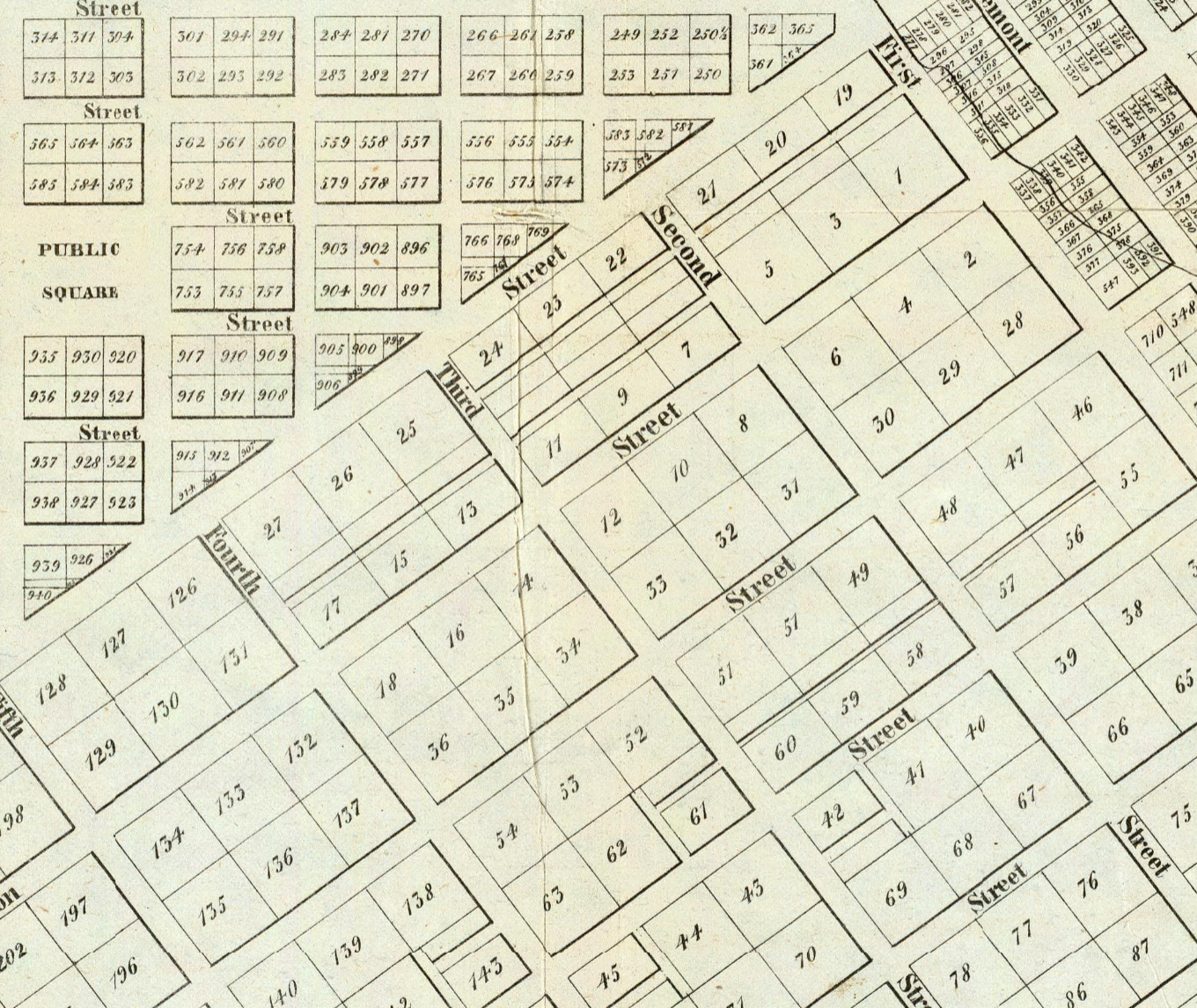
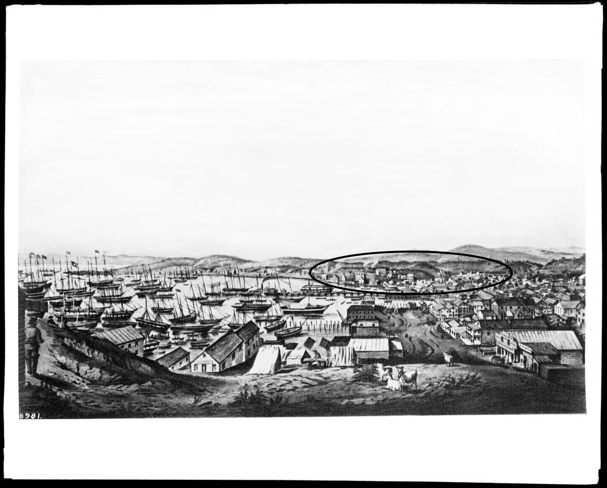
Firstly, the SOMA district at the time of the Gold Rush was one of SF’s first suburbs, a little ways south from the heart of the city (Portsmouth Square), as it exploded during the Gold Rush. This suburb, at that time, was known as Happy Valley, and was made up of cottage homes with land around them to the lot, mostly sand dunes and chaparral. [See drawing circa 1850 down at bottom of post.] It wasn’t urban by any measure, and as seen from William Eddy’s 1849 expansion of Jasper O’Farrell’s initial plat (see above), the first alleys in the area (in some cases access for horse and buggy or due to topography of area), between Market and Mission, were Jessie and Stevenson streets. I’m sure Jessie Street has been said to be named after a prostitute at some point since, but it was named for Jessie Benton Fremont, who during the Gold Rush lived in San Francisco, was the daughter of a well-regarded Missouri senator, and married to John C. Fremont, who was famous for his western explorations, as well as his Bear Flag antics during the beginning of the Mexican-American War, among other things. Also of note, Fremont went on to become the first Republican candidate for President in the United States in 1856. Stevenson Street was named for another somewhat famous San Franciscan of the era, Jonathan D. Stevenson, who had led the First Regiment of New York Volunteers during the Mexican-American War that came to California, and was therefore an early settler of SF before the Gold Rush, living in a house up around the SW corner of California and Stockton streets today. The other alley down in this vicinity on Eddy’s 1849 map, roughly running between First and Third, Howard and Folsom, is Clementina Street. That street is named for the ship Clementina that was a well-known ship at the middle of the 19th century, in fact, it had been the ship that brought John Sutter to Yerba Buena in 1839.
As for Minna: first mention of the street in SF papers I found was in April 1850 with regard to a lot/mortgage sale, it being instituted between Mission and Howard in the wake of Eddy’s map. Keep in mind, these side streets were instituted due to lots and where houses faced within the topography, as the neighborhood grew. But why would they name this new street Minna?
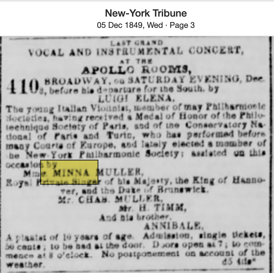
Searching NYC papers (note you cant really search SF papers in 1849 because they were mostly all shut down until the very end of the year), I found there was an active bark ship called the Minna that’s main port was in Bremen, Germany; furthermore, after more digging, I’ll bet you another 100 gold pieces that that ship was named for Minna Muller who at the time was the Royal private singer of the King of Hanover/Duke of Brunswick. She traveled and performed in NYC in 1849. Singers like Minna were world famous during this era, for instance see Jenny Lind of Sweden (One of SF’s first/main theaters was named after her though she never came to SF). Could have been there were some German settlers in the area, as well (I’m pretty sure there were German farmers settled in the SOMA area (nearer the Mission) in the Yerba Buena days, so makes sense, but don’t make me pull my Bancroft books down right now). It may seem crazy today that a good ole Google search basically pulls up nothing for Minna Muller, but she’s just lost to history, like many others. But given the time and circumstances and reality? That’s who Minna Street is named for, versus some mysterious courtesan.
[PS: Thanks to Colin Frangos for giving me the nudge on this one.]